Dallas-Fort Worth Eight-Hour Ozone SIP Modeling (2006 Episode): MM5 Modeling Domain
Meteorological modeling (MM5) domain: horizontal grid and vertical layer structures for the Dallas-Fort Worth 8-hour ozone SIP revision (2006 episode).
Following are the MM5 horizontal grid and vertical layer structures used in the 2006 Dallas-Fort Worth eight-hour ozone SIP modeling (DFW8H2).
Horizontal Grid Structure
The MM5 modeling domain is defined from the Lambert Conformal Conic map projection.
| First True Latitude (Alpha): | 30ºN |
| Second True Latitude (Beta): | 60ºN |
| Central Longitude (Gamma): | 100ºW |
| Projection Origin: | (100ºW, 40ºN) |
| Spheroid: | Perfect Sphere, Radius = 6370 km |
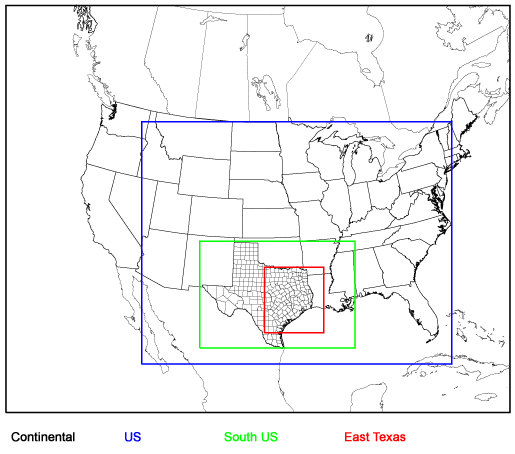
The horizontal modeling domain grid structure consists of a coarse grid continental domain and four nested subdomains: the Continental Domain, U.S. Domain, South U.S. Domain, and East Texas Domain.
| Domain Name | Range (km) | Number of Grid Points | Cell Size (km) | Domain Number in MM5 |
|||
|---|---|---|---|---|---|---|---|
| Easting | Northing | Easting | Northing | Easting | Northing | ||
| Continental Domain | (-2808,2808) | (-2268,2268) | 53 | 43 | 108 | 108 | 1 |
| U.S. Domain | (-1296,2160) | (-1728,972) | 97 | 76 | 36 | 36 | 2 |
| South U.S. Domain | (-648,1080) | (-1548,-360) | 145 | 100 | 12 | 12 | 3 |
| East Texas Domain | (72,732) | (-1380,-648) | 166 | 184 | 4 | 4 | 4 |
DFW8H2 MM5 Modeling Domain
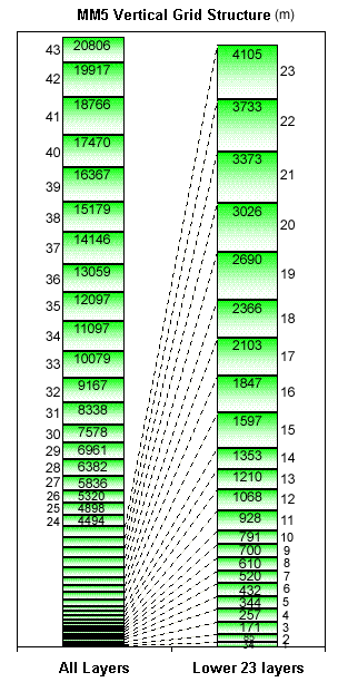
Vertical Layer Structure
| Layer | Sigma | Layer Top (m AGL) |
Center (m AGL) |
Thickness (m) |
|---|---|---|---|---|
| 43 | 0.000 | 20806.8 | 20362.1 | 889.6 |
| 42 | 0.010 | 19917.3 | 19341.4 | 1151.7 |
| 41 | 0.025 | 18765.6 | 18117.9 | 1295.3 |
| 40 | 0.045 | 17470.3 | 16918.8 | 1103.1 |
| 39 | 0.065 | 16367.2 | 15773.2 | 1188.1 |
| 38 | 0.090 | 15179.1 | 14662.7 | 1032.8 |
| 37 | 0.115 | 14146.3 | 13602.4 | 1087.8 |
| 36 | 0.145 | 13058.5 | 12577.6 | 961.9 |
| 35 | 0.175 | 12096.6 | 11596.6 | 1000.0 |
| 34 | 0.210 | 11096.7 | 10587.9 | 1017.5 |
| 33 | 0.250 | 10079.1 | 9622.9 | 912.6 |
| 32 | 0.290 | 9166.6 | 8752.3 | 828.6 |
| 31 | 0.330 | 8338.0 | 7958.1 | 759.8 |
| 30 | 0.370 | 7578.2 | 7269.5 | 617.3 |
| 29 | 0.405 | 6960.9 | 6671.3 | 579.2 |
| 28 | 0.440 | 6381.7 | 6108.8 | 545.8 |
| 27 | 0.475 | 5835.9 | 5577.7 | 516.3 |
| 26 | 0.510 | 5319.5 | 5108.7 | 421.6 |
| 25 | 0.540 | 4898.0 | 4695.9 | 404.0 |
| 24 | 0.570 | 4493.9 | 4299.9 | 388.0 |
| 23 | 0.600 | 4105.9 | 3919.3 | 373.3 |
| 22 | 0.630 | 3732.7 | 3552.8 | 359.7 |
| 21 | 0.660 | 3373.0 | 3199.5 | 347.1 |
| 20 | 0.690 | 3025.9 | 2858.2 | 335.5 |
| 19 | 0.720 | 2690.4 | 2528.1 | 324.6 |
| 18 | 0.750 | 2365.8 | 2234.4 | 262.8 |
| 17 | 0.775 | 2103.0 | 1974.9 | 256.1 |
| 16 | 0.800 | 1846.9 | 1721.9 | 249.8 |
| 15 | 0.825 | 1597.0 | 1475.1 | 243.9 |
| 14 | 0.850 | 1353.2 | 1281.4 | 143.6 |
| 13 | 0.865 | 1209.6 | 1138.8 | 141.6 |
| 12 | 0.880 | 1068.0 | 998.1 | 139.7 |
| 11 | 0.895 | 928.3 | 859.4 | 137.8 |
| 10 | 0.910 | 790.5 | 745.0 | 90.9 |
| 9 | 0.920 | 699.6 | 654.6 | 90.1 |
| 8 | 0.930 | 609.5 | 564.9 | 89.3 |
| 7 | 0.940 | 520.2 | 476.0 | 88.5 |
| 6 | 0.950 | 431.7 | 387.8 | 87.8 |
| 5 | 0.960 | 343.9 | 300.4 | 87.0 |
| 4 | 0.970 | 256.9 | 213.7 | 86.3 |
| 3 | 0.980 | 170.5 | 127.7 | 85.6 |
| 2 | 0.990 | 84.9 | 59.4 | 51.0 |
| 1 | 0.996 | 33.9 | 16.9 | 33.9 |
| 0 | 1.000 | 0.0 | 0.0 | 0.0 |