Gulf Coast Oyster Waters

Counties: Brazoria, Chambers, Galveston, Harris
Parameter: Bacteria in Oyster Waters
Basins: Neches-Trinity Coastal, Trinity River, San Jacinto River, and San Jacinto–Brazos Coastal, Bays and Estuaries
Segments: 2421, 2422, 2423, 2424, 2432, 2433, 2434, 2435, 2439
On this page:
- Background and Goals
- Watershed Description
- Get Involved
- Approved I-Plan
- Adopted TMDLs
- For More Information
Background and Goals
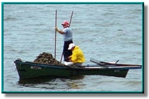
Oyster harvests are an important economic resource in coastal areas. Data assessed in 2002 showed that localized sections of bay segments on the Upper Texas Coast were not suitable for harvesting shellfish because of elevated bacteria concentrations. Microorganisms from human and animal waste may contaminate oysters and other shellfish, making them unsafe to eat, especially since some shellfish are eaten raw. Oyster harvesting, also called the “oyster waters use,” is the most commonly impaired use among Texas coastal waters, and restricted areas are closed to the harvesting of shellfish for direct marketing.
Assessment of the oyster waters use is conducted by the Seafood Safety Division of the Texas Department of State Health Services. The DSHS is responsible for monitoring and classifying shellfish harvest areas into four categories for harvesting—approved, conditionally approved, restricted, or prohibited. These classifications are published as maps on the DSHS website .
The goal of this project is to improve water quality so that the oyster beds are routinely safe for harvesting. Analysis indicates that isolated zones of high bacteria concentrations occur in isolated areas near shorelines, rather than occurring chronically throughout the bays. Because the exceedances are confined to discrete areas, bay-wide reductions can be achieved by targeting each isolated zone.
Watershed Description
The original upper Texas coast project included six segments:
- Upper Galveston Bay (Segment 2421)
- Trinity Bay (Segment 2422)
- East Bay (Segment 2423)
- West Bay (Segment 2424)
- Chocolate Bay (Segment 2432)
- Lower Galveston Bay (Segment 2439)
In 2012, three additional segments were added to the project area:
- Bastrop Bay/Oyster Lake (Segment 2433OW)
- Christmas Bay, (Segment 2434OW)
- Drum Bay, (Segment 2435OW)
These segments lie within the Neches-Trinity Coastal Basin, Trinity River Basin, San Jacinto River Basin, and the San Jacinto-Brazos Coastal Basin.
Get Involved
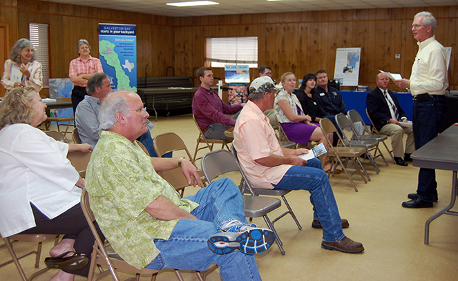
The Galveston Bay Foundation coordinated stakeholder participation in developing the I-Plan. Work groups were formed at a public meeting on Feb. 24, 2010, and were held regularly while the I-Plan was being developed.
The Galveston Bay Foundation coordinated stakeholder participation in the development of the TMDLs and I-Plan under a contract with the Houston–Galveston Area Council. To get involved with implementing the plan, visit the Galveston Bay Foundation Volunteer webpage , or contact Emily Ford at eford@galvbay.org.
Approved I-Plan
Stakeholders in the region developed this I-Plan. On August 19, 2015, the commission approved their plan.
Status
Tracking of implementation allows stakeholders to evaluate actions taken, identify actions that may not be working, and make changes as necessary.
Adopted TMDLs
On Aug. 20, 2008, the commission adopted the six original TMDLs below. On Feb. 4, 2009, the EPA approved these TMDLs, at which time they became part of the state’s Water Quality Management Plan.
-
Six TMDLs for Bacteria in Waters of the Upper Gulf Coast
Segments: 2421, 2422, 2423, 2424, 2432, and 2439
(Includes an amendment in Appendix C that gives the median fecal coliform capacity of the restricted oyster-water assessment units; this also serves as Addendum 1 to the original document.) - Response to Public Comment on the TMDLs
TMDLs for three additional segments, 2433, 2434, and 2435, were added by addenda in 2012 (see below).
Revisions to TMDLs
From time to time, it is necessary to revise TMDLs to account for changing conditions in the watershed. Revisions to the load allocations in TMDLs are made via the state’s Water Quality Management Plan (WQMP), which is updated quarterly.
The WQMP provides projected effluent limits for use in planning and permitting activities under the Texas Pollutant Discharge Elimination System (TPDES). The TCEQ reviews all applications for new and amended permits for conformance with applicable portions of the WQMP, including adopted TMDLs.
Revisions are made to TMDLs in one of two ways:
- Updates are made to account for changing conditions in the watershed, such as new or revised wasteload allocations, permits that have been canceled or have expired, or changed facility names.
- Addenda are created to add load allocations for assessment units that are impaired by the same pollutant or condition, within the same watershed as in the original TMDL report.
Both updates and addenda are provided in the same units of measure used in the original TMDL.
Addenda
Additional TMDLs for the Upper Texas Coast have been added by addenda.
- TMDL Addendum One: added as Appendix C in the
original TMDL report September 2009
Assessment Units: 2421_01, 2421_02, 2422_01, 2423_01, 2432_01, 2424_02, and 2439_01, -
TMDL Addendum Two: Two TMDLs for Bacteria in Drum Bay
Segment: 2435OW; Assessment Units: 2435OW_01 and 2435OW_02
January 2012 WQMP Update, Approved by EPA April 2012 -
TMDL Addendum Three: Two TMDLs for Bacteria in Bastrop Bay/Oyster Lake and Christmas Bay
Segments: 2433OW and 2434OW; Assessment Units: 2433OW_02 and 2434OW_01
April 2012 WQMP Update, Approved by EPA August 2012
Updates
Updates are made to account for changing conditions in the watershed, such as new or revised wasteload allocations, permits that have been canceled or have expired, or changed facility names. Updates use the same units of measure as the original TMDL.
- October 2018, Appendix III, page 15
- July 2018, Appendix IV, page 21
- October 2016, Appendix II, page 13
- October 2015, Appendix V, page 14
- January 2013, Appendix IV, page 14
- April 2012, Appendix II, page 11 (Bastrop Bay/Oyster Lake and Christmas Bay Addendum)
- January 2012, Appendix V, page 18 (Drum Bay Addendum)
- October 2010, Appendix III, page 14
- October 2009, Appendix III, page 15
- July 2009, Appendix V, page 12
- April 2009, Appendix V, page 21
WQMP updates may be viewed in person at the TCEQ Library, Building A, 12100 Park 35 Circle, Austin, Texas. Electronic versions of updates published from 2014 through the present are available on the Texas State Library and Archives Commission website .
For WQMP updates prior to 2014, use the TCEQ TRAIL Search as outlined below. The main search box on the page will only conduct a simple search with no exclusionary parameters and should not be used.
- First, limit your search to TCEQ only. Do this via the advanced search feature on the left of the page. To limit a search to TCEQ content, enter “www.tceq.texas.gov” or “www.tceq.state.tx.us” into the “From the Host” search box.
- Refine your search to narrow down results. The other search boxes on the left of the page allow for search terms to be included, excluded, or used in an exact phrase search. Date ranges can be used as well.
For More Information
Please email tmdl@tceq.texas.gov, and mention the Upper Coast Oyster Waters TMDL in the subject line. Or call us at 512-239-6682.