Hydrography Data and Map-Based Data Viewers
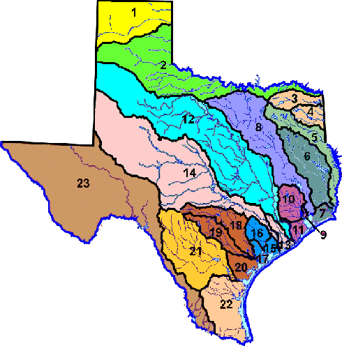
Major River and Coastal Basins of Texas
Texas river and coastal basins are numbered as part of a classification system TCEQ uses to support management of surface water resources. Segments (portions or reaches) of a basin are assigned numbers that begin with the basin number and add two additional numbers that identify a specific area of a water body: for example, Segment 0101 of the Canadian River.
1. Canadian River Basin
2. Red River Basin
3. Sulphur River Basin
4. Cypress Creek Basin
5. Sabine River Basin
6. Neches River Basin
7. Neches-Trinity Coastal Basin
8. Trinity River Basin
9. Trinity-San Jacinto Coastal Basin
10. San Jacinto River Basin
11. San Jacinto-Brazos Coastal Basin
12. Brazos River Basin
13. Brazos-Colorado Coastal Basin
14. Colorado River Basin
15. Colorado-Lavaca Coastal Basin
16. Lavaca River Basin
17. Lavaca-Guadalupe Coastal Basin
18. Guadalupe River Basin
19. San Antonio River Basin
20. San Antonio-Nueces Coastal Basin
21. Nueces River Basin
22. Nueces-Rio Grande Coastal Basin
23. Rio Grande Basin
24. Bays and Estuaries
Download a map of the 23 major Texas River Basins.
Data Viewers
Viewers use a map-based user interface to give access to data. These pages are sometimes slow to load.
- Surface Water Segment Viewer
Use this viewer to locate water bodies in Texas - Surface Water Quality Data Viewer
Use this viewer to locate monitoring stations and download water quality data - Edwards Aquifer Data
Recharge, contributing, and transition zones; boundaries - Other Viewers
GIS Data Sets
Data layers for use in ArcGIS. Includes data such as stream, lake, and bay segments; permitted wastewater outfalls; regulatory boundaries; and land use. Some file sizes are large and therefore may be slow to download or may "timeout" before download is complete.
- Texas Ecoregions - Maps and Data on the EPA website
- TCEQ Water Data
Stream segments, assessment units, monitoring stations, and more
For More Information
Contact us at 512-239-6682 or email tmdl@tceq.texas.gov and mention GIS data in the subject line.