Modeling Project Graphics
Downloads folder for Modeling Project Graphics


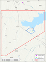
A map showing the area in Navarro County, Texas where the Streetman Plant is shown as a smaller area outlined in blue, within the larger Navarro 2010 SO2 NAAQS nonattainment area outlined in red. A Data Requirements Rule monitor, the Richland Southeast 1220 Road monitor, is shown as a green triangle in the middle of the Streetman Plant area. The National Weather Service monitor used for surface meteorological data, located at the Corsicana Municipal Airport, is marked as a purple plus-sign north of the Navarro nonattainment area.
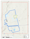
A map showing the Howard County sulfur dioxide nonattainment area. The Big spring Carbon Black Plant (Tokai), the Big spring Refinery (Delek), and BHER Power Resources (BHER) are three sources of SO2 emissions within the Howard County nonattainment area and are outlined in yellow, blue, and black, respectively, in the figure. A Data Requirements Rule monitor, the Big Spring Midway monitor, or Continuous Ambient Monitoring Station 1072 (C1072), was sited across North Midway Road approximately 0.15 kilometer to the northeast of the Tokai Plant to monitor SO2 concentrations. This monitor is shown as a green triangle in the figure.
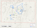
A map showing the Hutchinson County nonattainment area outlined in red. Within this area, the eight sulfur dioxide sources are shown, and outlined in blue. The sulfur dioxide monitor and surface meteorology monitor used for the attainment demonstration modeling for this area are shown as a green triangle in the west portion of the nonattainment area and a purple plus sign in the center of the nonattainment area, respectively.