Houston-Galveston-Brazoria 8-Hour Ozone SIP Modeling (2005/2006 Episodes): CAMx Modeling Domain
Photochemical model CAMx modeling domain: horizontal grid and vertical layer structures for the Houston-Galveston-Brazoria 8-hour ozone SIP revision (2005 and 2006 Episodes).
Following are the CAMx horizontal grid and vertical layer structures used for the 2005/2006 Houston-Galveston-Brazoria eight-hour ozone SIP modeling (HGB8H2).
Horizontal Grid Structure
The CAMx modeling domain is defined in the Lambert Conformal Conic map projection:
| First True Latitude (Alpha): | 30ºN |
| Second True Latitude (Beta): | 60ºN |
| Central Longitude (Gamma): | 100ºW |
| Projection Origin: | (100ºW, 40ºN) |
| Spheroid: | Perfect Sphere, Radius = 6370 km |
The horizontal modeling domain structure consists of a coarse-grid East US domain and nested fine-grid subdomains: East Texas subdomain, Houston-Galveston-Brazoria/Beaumont-Port Arthur (HGB/BPA) subdomain, and the Houston-Galveston (HG) subdomains.
| Domain Name | Range (km) | Number of Cells | Cell Size (km) | Name in CAMx |
|||
|---|---|---|---|---|---|---|---|
| Easting | Northing | Easting | Northing | Easting | Northing | ||
| East US Domain | (-108,2376) | (-1584,828) | 69 | 67 | 36 | 36 | eus_36km |
| East Texas Subdomain | (-12,1056) | (-1488,-420) | 89 | 89 | 12 | 12 | etx_12km |
| HGB/BPA Subdomain | (356,688) | (-1228,-968) | 83 | 65 | 4 | 4 | hgbpa_04km |
| HG Subdomain | (394,542) | (-1154,-1042) | 74 | 56 | 2 | 2 | hg_02km |
Vertical Layer Structure
| MM5 Layer |
Layer Top (m AGL) |
East US and East Texas Domains | HGB/BPA and HG Domains | ||||||
| CAMx Layer |
Center (m AGL) |
Thickness (m) |
CAMx Layer |
Center (m AGL) |
Thickness (m) |
||||
| 38 | 15179.1 | 17 | 12172.9 | 6012.5 | 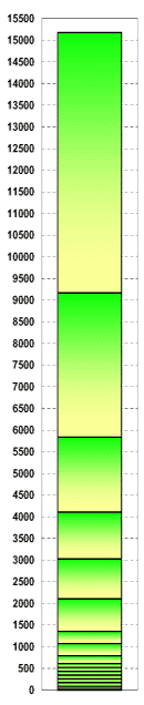 |
28 | 13637.9 | 3082.5 | 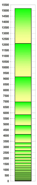 |
| 36 | 12096.6 | 27 | 10631.6 | 2930.0 | |||||
| 32 | 9166.6 | 16 | 7501.3 | 3330.7 | 26 | 8063.8 | 2205.7 | ||
| 29 | 6960.9 | 25 | 6398.4 | 1125.0 | |||||
| 27 | 5835.9 | 15 | 4970.9 | 1730.0 | 24 | 5367.0 | 937.9 | ||
| 25 | 4898.0 | 23 | 4502.2 | 791.6 | |||||
| 23 | 4106.4 | 14 | 3565.9 | 1080.0 | 22 | 3739.9 | 733.0 | ||
| 21 | 3373.5 | 21 | 3199.9 | 347.2 | |||||
| 20 | 3026.3 | 13 | 2564.5 | 922.9 | 20 | 2858.3 | 335.9 | ||
| 19 | 2690.4 | 19 | 2528.3 | 324.3 | |||||
| 18 | 2366.1 | 18 | 2234.7 | 262.8 | |||||
| 17 | 2103.3 | 12 | 1728.1 | 749.8 | 17 | 1975.2 | 256.2 | ||
| 16 | 1847.2 | 16 | 1722.2 | 249.9 | |||||
| 15 | 1597.3 | 15 | 1475.3 | 243.9 | |||||
| 14 | 1353.4 | 11 | 1210.6 | 285.2 | 14 | 1281.6 | 143.6 | ||
| 13 | 1209.8 | 13 | 1139.0 | 141.6 | |||||
| 12 | 1068.2 | 10 | 929.3 | 277.5 | 12 | 998.3 | 139.7 | ||
| 11 | 928.5 | 11 | 859.5 | 137.8 | |||||
| 10 | 790.6 | 9 | 700.0 | 181.0 | 10 | 745.2 | 90.9 | ||
| 9 | 699.7 | 9 | 654.7 | 90.1 | |||||
| 8 | 609.7 | 8 | 564.9 | 89.3 | 8 | 565.0 | 89.3 | ||
| 7 | 520.3 | 7 | 476.0 | 88.5 | 7 | 476.1 | 88.5 | ||
| 6 | 431.8 | 6 | 387.8 | 87.8 | 6 | 387.9 | 87.8 | ||
| 5 | 344.0 | 5 | 300.4 | 87.0 | 5 | 300.5 | 87.1 | ||
| 4 | 256.9 | 4 | 213.7 | 86.3 | 4 | 213.8 | 86.3 | ||
| 3 | 170.6 | 3 | 127.7 | 85.6 | 3 | 127.8 | 85.6 | ||
| 2 | 85.0 | 2 | 59.4 | 51.0 | 2 | 59.4 | 51.0 | ||
| 1 | 33.9 | 1 | 16.9 | 33.9 | 1 | 17.0 | 33.9 | ||
Note: AGL - Above ground level.