Caney Creek Tidal and Linnville Bayou
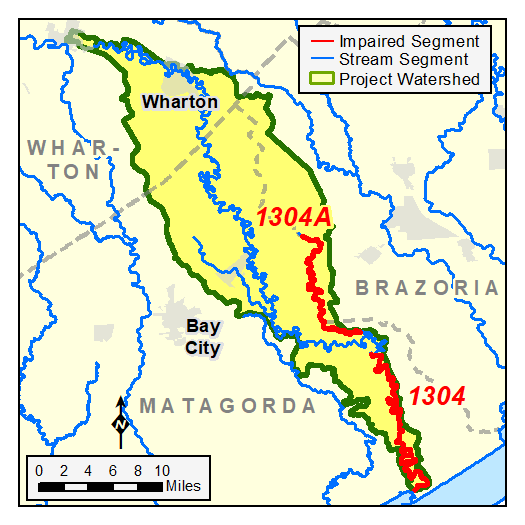

Counties: Matagorda, Brazoria, Wharton
Parameter: Bacteria
Basin: Brazos–Colorado Coastal
Segments: 1304, 1304A
Assessment Units (AUs): 1304_01, 1304A_01
On this page:
- Background and Goal
- Watershed Description
- Get Involved
- Approved I-Plan
- Adopted TMDLs
- Reports
- Contact Us
Background and Goal
High concentrations of bacteria, which are found in both human and animal waste, have been observed in certain assessment units of Caney Creek Tidal (Segment 1304, AU 1304_01) and Linnville Bayou (Segment 1304A, AU 1304A_01). The presence of these bacteria may indicate a health risk to people who swim or wade in the creek or bayou—activities referred to as "contact recreation" in the Texas Surface Water Quality Standards.
The goal of this project is to improve water quality to protect recreational uses. Toward that goal, TCEQ and stakeholders are developing total maximum daily loads (TMDLs) and an implementation plan (I-Plan) to reduce bacteria in the creek and bayou.
Watershed Description
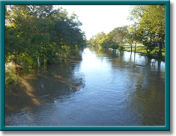
The Caney Creek watershed lies in southeast Texas near the Houston–Galveston area and includes the cities of Wharton, Boling-Iago, and Van Vleck. The watershed includes portions of Matagorda, Brazoria, and Wharton counties. Caney Creek flows southeastward before emptying into the Intracoastal Waterway (ICWW) near the northeast end of East Matagorda Bay.
The source of water in Caney Creek is mostly from rainfall runoff. The creek and its tributaries are generally sluggish due to the gentle sloping relief of the coastal plain. Creekside vegetation is still common along portions of the creek and remnant oxbows, particularly along Linnville Bayou. The tidal portion of the creek broadens slightly as it moves out over the coastal plain before reaching the ICWW.
The TMDL watershed is primarily coastal prairies and marshes, broken up by ribbons of riparian hardwoods and pine forests that are continually influenced by the sea, wind, rain, and hurricanes. Native vegetation includes tallgrass prairies, live oak woodlands, and a variety of salt-tolerant plants. Extensive wetland habitats provide food and shelter for numerous bird species and aquatic organisms. Developed land makes up only about 6% of the watershed.
Get Involved
Staff from the Houston–Galveston Area Council (H-GAC) have been working with communities, interest groups, and local organizations to distribute information about this project and involve stakeholders in developing the I-Plan for watershed improvement. Meeting information is posted on H-GAC's Brazos-Colorado Coastal Basin webpage . All public meetings about this project are open to anyone interested. Watch for meeting announcements here and on H-GAC's project webpage.
Approved I-Plan
Community stakeholders worked together to create the I-Plan. The Commission approved the stakeholders' plan on June 14, 2023.
- I-Plan for Two TMDLs for Indicator Bacteria in the Caney Creek Watershed
- Response to Public Comment on the I-Plan for the Caney Creek Watershed
Status of Activities
TCEQ provides opportunities for stakeholders to report on progress and changes in the watershed. Tracking of implementation progress allows stakeholders to evaluate actions taken, identify actions that may not be working, and make any changes as necessary.
Adopted TMDLs
The Commission adopted these TMDLs on Aug. 11, 2021. EPA approved them on Feb. 2, 2022, at which time they became an update to the state's Water Quality Management Plan.
- Two TMDLs for Indicator Bacteria in the Caney Creek Watershed, AS-206
- Response to Public Comments on the TMDLs for the Caney Creek Watershed
Revisions to TMDLs
From time to time, it is necessary to revise TMDLs to account for changing conditions in the watershed. Revisions to the load allocations in TMDLs are made via the state’s Water Quality Management Plan (WQMP), which is updated quarterly. The WQMP provides projected effluent limits for use in planning and permitting activities under the Texas Pollutant Discharge Elimination System (TPDES). The TCEQ reviews all applications for new and amended permits for conformance with applicable portions of the WQMP, including adopted TMDLs.
Revisions are made to TMDLs in one of two ways:
- Updates are made to account for changing conditions in the watershed, such as new or revised wasteload allocations, permits that have been canceled or have expired, or changed facility names.
- Addenda are created to add load allocations for assessment units that are impaired by the same pollutant or condition, within the same watershed as in the original TMDL report.
Addendum
Additional TMDLs have been added for the watershed by addendum:
-
Addendum One: One TMDL for Indicator Bacteria in Caney Creek Tidal
Segments: 1304; Assessment Unit: 1304_02
January 2024 WQMP Update. Approved by EPA April 17, 2024.
WQMP updates may be viewed in person at the TCEQ Library, Building A, 12100 Park 35 Circle, Austin, Texas. Electronic versions of updates are available on the TCEQ Water Quality Management Plan: Updates page.
Reports
H-GAC staff completed a technical report in 2019 that compiled and analyzed all available bacteria data and considered sources of the bacteria and their relative contributions.
Contact Us
Please email us at tmdl@tceq.texas.gov, and mention Caney Creek in the subject line. Or call us at 512-239-6682.