Tributaries of the Neches River Below Lake Palestine
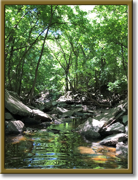
Photo courtesy of the Angelina and Neches River Authority


County: Angelina
Parameter: Bacteria
Basin: Neches River
Segments: 0604A, 0604B, 0604C, 0604M
Assessment Units (AUs): 0604A_02, 0604B_01, 0604C_01, 0604M_03
On this page:
- Background and Goal
- Watershed Description
- Get Involved
- Approved I-Plan
- Adopted TMDL
- Reports
- Contact Us
Background and Goal
In portions of four stream segments in the Lufkin area, bacteria concentrations are sometimes higher than the criteria set to protect the safety of recreation. High concentrations of bacteria, which are found in both human and animal waste, may indicate a health risk to people who swim or wade in the water body—activities called “contact recreation” in the state’s standards for water quality.
The goal of this project is to improve water quality to protect recreational uses. Toward that goal, the TCEQ and stakeholders are developing a total maximum daily load (TMDL) and an implementation plan (I-Plan) to reduce bacteria in the creeks.
Watershed Description
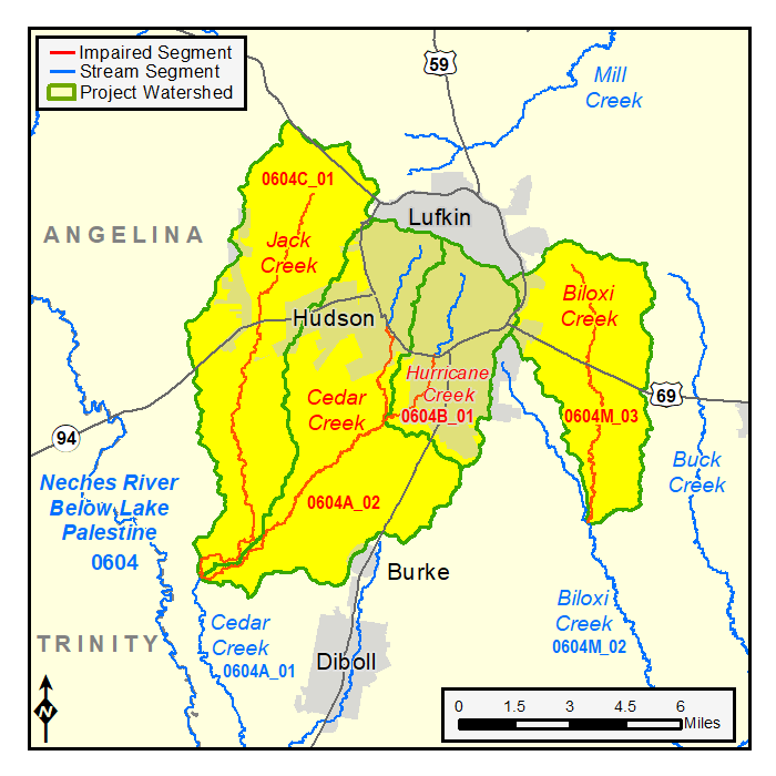
The watersheds lie in Angelina County in east Texas in the vicinity of Lufkin, and include the cities of Hudson and Lufkin. The project includes portions of Jack Creek, Cedar Creek, Hurricane Creek, and Biloxi Creek. The watershed area for this project is also referred to as Tributaries of the Neches River below Lake Palestine.
The project includes assessment units (AU) in four stream segments:
- Jack Creek (Segment 0604C)
From the confluence with Cedar Creek (0604A) upstream to confluence with unnamed tributary southwest of US Hwy 69 northwest of Lufkin. - Cedar Creek (Segment 0604A, AU 02)
From the confluence with Jack Creek (0604C) to the confluence with unnamed tributary adjacent to State Loop 287. This assessment area is the only impaired portion of the stream. - Hurricane Creek (Segment 0604B)
From the confluence with Cedar Creek (0604A) upstream to the headwaters near Groesbeck Ave in Lufkin. - Biloxi Creek (Segment 0604M, AU 03)
From the confluence with One Eye Creek in Angelina County southeast of Lufkin upstream to FM 325 east of Lufkin. This assessment area is the only impaired portion of the stream.
The Jack Creek watershed, which includes portions of the city of Hudson, is about 29 square miles. The dominant land cover includes hay/pasture (33%), forest (33%) and developed (13%).
The Cedar Creek watershed is about 32 square miles. The dominant land cover includes forest (37%), developed (25%), and hay/pasture (19%). It includes portions of the cities of Hudson and Lufkin.
The Hurricane Creek watershed, which includes portions of Lufkin, is about 13 square miles. The dominant land cover includes developed (66%) and forest (22%).
The Biloxi Creek watershed is about 19 square miles. The dominant land cover includes forest (37%), hay/pasture (31%), and developed (17%). It includes small portions of Lufkin.
Get Involved
Staff from the Texas Water Resources Institute (TWRI) are working with communities, interest groups, and local organizations to distribute information about this project and involve stakeholders in developing the I-Plan for watershed improvement. All public meetings about this project are open to anyone interested. Watch for meeting announcements here and on the TWRI website .
Meeting Records
- Meeting Summary, June 6, 2021
- Meeting Summary, March 25, 2021
- Meeting Summary, Nov. 30, 2020
- Meeting Summary, July 7, 2020
- Meeting Summary, Nov. 22, 2019
Approved I-Plan
Community stakeholders worked together to create the I-Plan. The Commission approved the stakeholders' plan on Aug. 16, 2023.
- I-Plan for Four TMDLs for Indicator Bacteria in Tributaries of the Neches River below Lake Palestine
- Response to Public Comments on the I-Plan (no comments were received)
Status
TCEQ provides opportunities for stakeholders to report on progress and changes in the watershed. Tracking of implementation progress allows stakeholders to evaluate actions taken, identify actions that may not be working, and make any changes as necessary.
- Year One Implementation Status Update, October 2024
- Year Two Implementation Status Update, July 2025
Adopted TMDLs
The Commission adopted these TMDL on Oct. 5, 2022. On June 7, 2023, EPA approved the TMDLs, at which time they became part of the state’s Water Quality Management Plan (WQMP).
- Four TMDLs for Indicator Bacteria in Tributaries of the Neches River below Lake Palestine
- Response to Comments for TMDLs (no comments were received)
Revisions to the TMDLs
From time to time, it is necessary to revise TMDLs to account for changing conditions in the watershed. Revisions to the load allocations in TMDLs are made via the state’s Water Quality Management Plan, which is updated quarterly. The WQMP provides projected effluent limits for use in planning and permitting activities under the Texas Pollutant Discharge Elimination System (TPDES). The TCEQ reviews all applications for new and amended permits for conformance with applicable portions of the WQMP, including adopted TMDLs.
Revisions are made to TMDLs in one of two ways:
- Updates are made to account for changing conditions in the watershed, such as new or revised wasteload allocations, permits that have been canceled or have expired, or changed facility names.
- Addenda are created to add load allocations for assessment units that are impaired by the same pollutant or condition, within the same watershed as in the original TMDL report.
Addendum
Additional TMDLs have been added for the watershed by addendum:
-
Addendum One: One TMDL for Indicator Bacteria in Cedar Creek
Segments: 0604A; Assessment Unit: 0604A_03
January 2024 WQMP Update. Approved by EPA April 17, 2024.
WQMP updates may be viewed in person at the TCEQ Library, Building A, 12100 Park 35 Circle, Austin, Texas. Electronic versions of updates are available on the TCEQ Water Quality Management Plan: Updates page.
Reports
Contact Us
Please e-mail tmdl@tceq.texas.gov, and mention the Lufkin Area Watersheds project in the subject line. Or call us at 512-239-6682.