Today's Texas Air Quality Forecast
The latest forecast for air quality conditions in Texas' metropolitan areas.
March 5, 2026
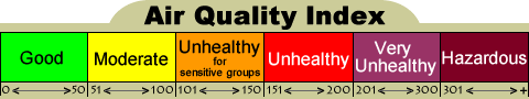
Forecast is for Ozone, PM2.5, & PM10, and is based on EPA's Air Quality Index (AQI)
| Forecast Region (Click name for AIRNOW version) |
Thu 03/05/2026 |
Fri 03/06/2026 |
Sat 03/07/2026 |
Sun 03/08/2026 |
|
|---|---|---|---|---|---|
| Amarillo | Good | Good | Good | Good | |
| Austin | PM2.5 | PM2.5 | Good | Good | |
| Beaumont-Port Arthur | Good | Good | Good | Good | |
| Big Bend | Good | Good | Good | Good | |
| Brownsville-McAllen | PM2.5 | PM2.5 | PM2.5 | PM2.5 | |
| Bryan-College Station | Good | Good | Good | Good | |
| Corpus Christi | PM2.5 | PM2.5 | PM2.5 | PM2.5 | |
| Dallas-Fort Worth | Good | Good | Good | Good | |
| El Paso | PM10^ | PM2.5/PM10 | PM2.5/PM10 | Good | |
| Houston | PM2.5 | PM2.5 | PM2.5 | PM2.5 | |
| Laredo | PM2.5 | PM2.5 | PM2.5 | PM2.5 | |
| Lubbock | Good | Good | Good | Good | |
| Midland-Odessa | PM2.5 | Good | Good | Good | |
| San Antonio | PM2.5 | PM2.5 | Good | Good | |
| Tyler-Longview | Good | Good | Good | Good | |
| Victoria | PM2.5 | PM2.5 | Good | Good | |
| Waco-Killeen | Good | Good | Good | Good | |
| An asterisk (*) indicates that an Ozone Action Day is or will be in effect for the indicated region. | |||||
| A caret (^) indicates that levels of PM may exceed the applicable short-term NAAQS. For more information see the following TCEQ websites:Air Pollution from Particulate Matter and Voluntary Tips for Citizens and Business to Reduce Emissions. | |||||
Forecast Discussion
Insufficient afternoon sunshine, gusty winds, and/or lower incoming background levels are forecast to be enough for ozone to stay in the "Good" range for the majority of areas statewide.
Southerly winds east of a dry line that is currently extending from the Panhandle through the Permian Basin has advected light density smoke and aerosols associated with burning and industrial activity in central and southern Mexico into portions of deep South Texas and will likely spread along the Southeast coast of Texas as the day progresses. With high relative humidity remaining in the eastern two thirds of the state, elevated fine particulate matter will endure but breezy winds and vertical mixing, facilitating dispersion, will likely mitigate these effects in North Central and Northeast Texas. Meanwhile, industrial activity in the Permian Basin is forecast to keep light density smoke and aerosols in the region; and when combined with increased moisture could sustain slightly elevated fine particulate matter throughout the day. Overall, the daily PM2.5 AQI may remain at the lower end of the "Moderate" range in parts of the Austin, Brownsville-McAllen, Corpus Christi, Houston, Laredo, Midland-Odessa, San Antonio, and Victoria areas and the upper end of the "Good" range (possibly with an isolated low "Moderate") in a majority of the Beaumont-Port Arthur, Bryan-College Station, Dallas-Fort Worth, Tyler-Longview, and Waco-Killeen areas. The daily PM10 AQI could reach the upper end of the "Good" range in a majority of the Houston area as well.
Gusty afternoon and evening winds will generate areas of blowing dust in far West Texas as well as possibly transporting dust out of northern Mexico into the region, with the daily PM10 AQI possibly reaching the middle to upper end of the "Unhealthy" range (possibly with occasional spikes into the "Very Unhealthy" or "Hazardous" ranges) in parts of the El Paso area while the PM2.5 AQI reaches the middle to upper end of the "Unhealthy for Sensitive Groups" range. Additionally, with severe storms possible from the Panhandle to the Permian Basin, blowing dust will be possible with any stronger outflows that manage to develop, however the coverage and duration are not expected to increase the daily PM2.5 AQI beyond the upper end of the "Good" range in a majority of the Amarillo and Lubbock areas.
Warm temperatures, sufficient afternoon sunshine, and/or slightly elevated lingering background levels could be enough for ozone to reach the upper end of the "Good" range in a majority of the Amarillo, Houston, Lubbock, and Midland-Odessa areas.
Breezy southerly winds will continue to advect moisture out of the Gulf into the eastern two thirds of Texas ahead of a dry line that is forecast to extend from the Panhandle through the Permian Basin. Depending on the burning and industrial activity in central and southern Mexico, light density smoke and aerosols could be transported into deep South, South Central, and Southeast Texas, although transport farther north cannot be ruled out. Additionally, a few scattered burnings in East/Southeast Texas could also produce light density smoke that affects these regions as well as the areas downwind, north of this activity. While the combination of high relative humidity and residual smoke could result in elevated fine particulate matter, the breezy winds as well as scattered precipitations could provide sufficient dispersion that precludes widespread coverage. Overall, the daily PM2.5 AQI may remain at the lower end of the "Moderate" range in parts of the Austin, Brownsville-McAllen, Corpus Christi, Houston, Laredo, San Antonio, and Victoria areas and the upper end of the "Good" range in a majority of the Beaumont-Port Arthur, Bryan-College Station, Dallas-Fort Worth, Tyler-Longview, and Waco-Killeen areas.
Suspended dust kicked up the previous day could sustain elevated fine particulate concentrations in far West Texas although occasionally breezy winds could help with dispersion, particularly in the morning and early afternoon. The daily PM2.5/PM10 AQIs could net out in the lower to middle of the "Moderate" range in parts of the El Paso area.
Insufficient afternoon sunshine, gusty winds, and/or lower incoming background levels are forecast to be enough for ozone to stay in the "Good" range for the majority of areas statewide.
A cold front is forecast to reach Central Texas Saturday morning with southerly winds continuing to advect moisture out of the Gulf near and ahead of the boundary. Depending on the gas flaring and industrial activity in central and southern Mexico, light density smoke and aerosol emissions will likely continue to be transported into portions of South and Southeast Texas as well as South Central Texas. While the combination of high relative humidity and smoke could keep fine particulate matter elevated in the affected regions, vertical mixing, widespread precipitation, and breezy winds associated with the front is expected to provide sufficient dispersion, particularly in Central and South-Central Texas. Overall, the daily PM2.5 AQI may remain at the lower end of the "Moderate" range in parts of the Brownsville-McAllen, Corpus Christi, Houston, and Laredo areas and the upper end of the "Good" range in a majority of the Austin, Beaumont-Port Arthur, Bryan-College Station, Dallas-Fort Worth, San Antonio, Tyler-Longview, Victoria, and Waco-Killeen areas.
Gusty winds in far West Texas could produce occasional areas of patchy blowing dust but the coverage and duration are not expected to raise the PM2.5/PM10 AQIs beyond the middle of the "Moderate" range in parts of the El Paso area.
Insufficient afternoon sunshine, gusty winds, and/or lower incoming background levels are forecast to be enough for ozone to stay in the "Good" range for the majority of areas statewide.
Depending on the gas flaring and industrial activity in central and southern Mexico, light smoke and aerosols could continue affecting portions of deep South Texas and the coastal bend of Texas. The aforementioned front is forecast to stall across the former as moisture is transported northward ahead of the boundary and will facilitate fine particulate formation, but precipitation associated with the front will mitigate these effects in Central, East, and Southeast Texas. Meanwhile, lighter winds in North Central and Northeast Texas could increase urban fine particulate matter but drier air due to northerly winds and precipitation washing out pollutants the previous day will keep PM2.5 levels only slightly elevated. Overall, the daily PM2.5 AQI may remain at the lower end of the "Moderate" range in parts of the Brownsville-McAllen, Corpus Christi, Houston, and Laredo areas and the upper end of the "Good" range in a majority of the Austin, Beaumont-Port Arthur, Bryan-College Station, Dallas-Fort Worth, San Antonio, Tyler-Longview, Victoria, and Waco-Killeen areas.
Light to moderate winds could sustain occasional slightly elevated urban fine particulate matter, but breezy winds from the previous day combined with sufficient dispersion on Sunday, the daily PM2.5/PM10 AQIs are forecast to net out in the upper end of the "Good" range in a majority of the regions, which includes the city of El Paso.
This forecast was last updated at 11:10 AM on Thursday, March 5th and is updated daily on normal TCEQ workdays and may also be updated on weekends or holidays when air pollution levels are high. Regardless of our forecast, we always recommend that each individual determine what level of activity they should conduct based on the actual local conditions. See the "Related Current Data" links below to monitor the latest actual conditions.
Related Items
Related Current Data
