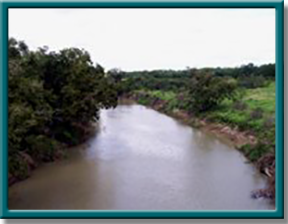
Upper San Antonio River
Watershed Counties: Bexar, Karnes, Wilson
Parameter: Bacteria
Basin: San Antonio River
Segments: 1910, 1910A, and 1911
On this page:
- Overview and Goal
- Watershed Description
- Get Involved
- Status
- Approved I-Plan
- Adopted TMDLs
- Reports and Other Documents
- Contact Us
Overview and Goal
In 2000, three segments—the Upper San Antonio River, Segment 1911; Salado Creek, Segment 1910; and Walzem Creek, Segment 1910A—did not meet the contact recreation standards. Bacteria are commonly found in the intestines of warm-blooded organisms such as humans, livestock, poultry, cats, and dogs. High levels of bacteria may pose a risk to people who swim or wade in them—activities called “contact recreation” in the state's standards for water quality.
In response to these conditions, TCEQ initiated a total maximum daily load (TMDL) project to determine the measures necessary to improve water quality in these waterbodies.
A TMDL is like a budget for pollution-it determines the amount (or load) of a pollutant that a body of water can receive and still be suitable for all its uses. The allowable load is then allocated among categories of sources within the watershed. Stakeholders work with the state to develop an implementation plan (I-Plan) to implement the TMDLs with measures that reduce pollution.
The goal of this current project is to reduce bacteria levels in parts of the San Antonio River, making them safer for recreation. Texas AgriLife Research and the San Antonio River Authority (SARA) are key partners in this project.
Watershed Description
The Upper San Antonio River, Segment 1911, is located in the central portion of the San Antonio River Basin. Its headwaters are in southeastern Bexar County within the City of San Antonio. The river runs north to south, from the southern end of San Antonio, past Floresville and Poth, to FM 791 near Falls City in Karnes County. The upper portion of the watershed is largely developed, while land use in the lower portion is agricultural and rangeland.
Salado Creek, Segment 1910, is located in the upper portion of the San Antonio River Basin, with its headwaters in north-central Bexar County. It flows north to south for 35 miles along the north and east side of San Antonio. Salado Creek joins the San Antonio River south of the city between Losoya and Elmendorf. Walzem Creek, Segment 1910A, is a small a tributary of Salado Creek. The upper portion is largely undeveloped, and the terrain is characterized by limestone hills and sparse vegetation.
Get Involved
In all our projects, we seek opinions and information from stakeholders—people who represent government, permitted facilities, agriculture, business, environmental, and community and private interests in the watershed. Texas AgriLife coordinated with people in the watershed to develop the I-Plan. A coordination committee representing diverse interests developed the plan.
All stakeholders are welcome to get involved in implementing the strategy to improve water quality. Public meetings about the project are open to everyone. Find out more about what it means to participate in TMDL projects.
Status
Tracking of implementation progress allows stakeholders to evaluate actions taken, identify actions that may not be working, and make any changes as necessary.
Approved I-Plan
The TCEQ and Texas AgriLife worked with stakeholders to develop an I-Plan for the project watersheds. The I-Plan will complement the existing watershed protection plan (WPP) for the Upper San Antonio River.
The WPP, which was updated in 2014, was originally developed by SARA in 2007, together with stakeholders, the City of San Antonio, Bexar County, and other partners. The WPP was developed to allow early implementation of measures to reduce pollution; environmental improvement targets were based on data and information in the TMDL report.
On April 6, 2016, the commission approved the I-Plan.
- I-Plan for Three TMDLs for Indicator Bacteria in the Upper San Antonio Watershed
- Response to Comments on the I-Plan
Adopted TMDLs
The commission adopted the original TMDLs on July 25, 2007. EPA approved them on Sept. 25, 2007, at which time they became part of the state's Water Quality Management Plan (WQMP).
-
Three TMDLs for Bacteria in the San Antonio Area
Segments: 1910, 1910A, and 1911 - Response to Public Comment on the TMDLs
Revisions to the TMDLs
From time to time, it is necessary to revise TMDLs to account for changing conditions in the watershed. Revisions to the load allocations in TMDLs are made via the state’s Water Quality Management Plan, which is updated quarterly.
The WQMP provides projected effluent limits for use in planning and permitting activities under the Texas Pollutant Discharge Elimination System (TPDES). The TCEQ reviews all applications for new and amended permits for conformance with applicable portions of the WQMP, including adopted TMDLs.
Revisions are made to TMDLs in one of two ways:
- Addenda are created to add load allocations for assessment units that are impaired by the same pollutant or condition, within the same watershed as in the original TMDL report.
- Updates are made to account for changing conditions in the watershed, such as new or revised wasteload allocations, permits that have been canceled or have expired, or changed facility names.
Both addenda and updates are provided in the same units of measure used in the original TMDL.
Addenda
-
Addendum One: Seven TMDLs for Bacteria in the Upper San Antonio River Watershed
Segments: 1910D, 1911B, 1911C, 1911D, and 1911E; Assessment Units: 1910D_01, 1911B_01, 1911C_01, 1911C_02, 1911D_01, 1911D_02, and 1911E_01
April 2016 WQMP Update, Approved by EPA Aug. 9, 2016. -
Addendum Two: One TMDL for Bacteria in Martinez Creek
Segment 1911I, Assessment Unit 1911I_01
October 2019 WQMP Update, Approved by EPA March 11, 2020.
Updates
- July 2022, Appendix VII, pages 30-31
- April 2021, Appendix VII, pages 25-26
- October 2015, Appendix VI, page 15
- April 2015, Appendix V, page 32
- October 2014, Appendix V, page 17
- July 2014, Appendix VI, page 39
- April 2009, Appendix III, pages 18-19
- April 2010, Appendix IV, pages 19-20
WQMP updates may be viewed in person at the TCEQ Library, Building A, 12100 Park 35 Circle, Austin, Texas. Electronic versions of updates published from 2014 through the present are available on the Texas State Library and Archives Commission website .
For WQMP updates prior to 2014, use the TRAIL Search engine as outlined below. The main search box on the page will only conduct a simple search with no exclusionary parameters and should not be used.
- First, limit your search to TCEQ only. Do this via the advanced search feature on the left of the page. To limit a search to TCEQ content, enter www.tceq.texas.gov or www.tceq.state.tx.us into the “From the Host” search box.
- Refine your search to narrow down results. The other search boxes on the left of the page allow for search terms to be included, excluded, or used in an exact phrase search. Date ranges can be used as well.
Reports and Other Documents
- Technical Support Document for Seven TMDL Additions, January 2015
- Technical Support Document for Martinez Creek TMDL Addition, July 2019
- BMP Assessment, February 2014
Contact Us
Please email tmdl@tceq.texas.gov and mention the Upper San Antonio River Bacteria TMDL in the subject line. Or call us at 512-239-6682.


 Back to top