Corpus Christi Beaches
This community project was started to reduce bacteria and protect recreational safety at beaches along Corpus Christi Bay. The total maximum daily loads (TMDLs) for waters adjacent to Cole and Ropes Park beaches have been adopted, as have the TMDLs for Poenisch Park. Stakeholders and TCEQ have developed an implementation plan (I-Plan) for all three beach areas. Together, the adopted TMDLs and approved I-Plan are the road map to improving water quality.

County: Nueces
Parameter: Bacteria
River Basin: Bays and Estuaries, Nueces River
Segment: 2481CB
Assessment Units (AUs): 2481CB_03, 2481CB_04, and 2481CB_06
On this page:
- Background and Goals
- Watershed Description
- Get Involved
- Approved I-Plan
- Adopted TMDLs
- Reports
- Contact Us
Background and Goals
High concentrations of bacteria may indicate a health risk to people who swim or wade in a water body—activities called “contact recreation” in the state’s standards for water quality.
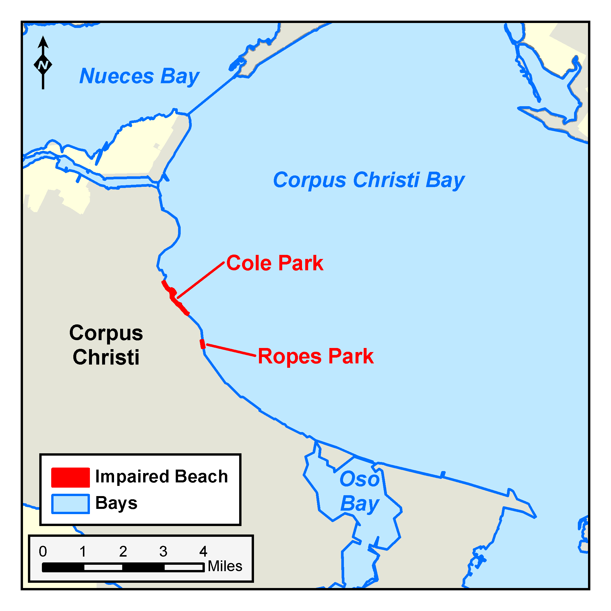
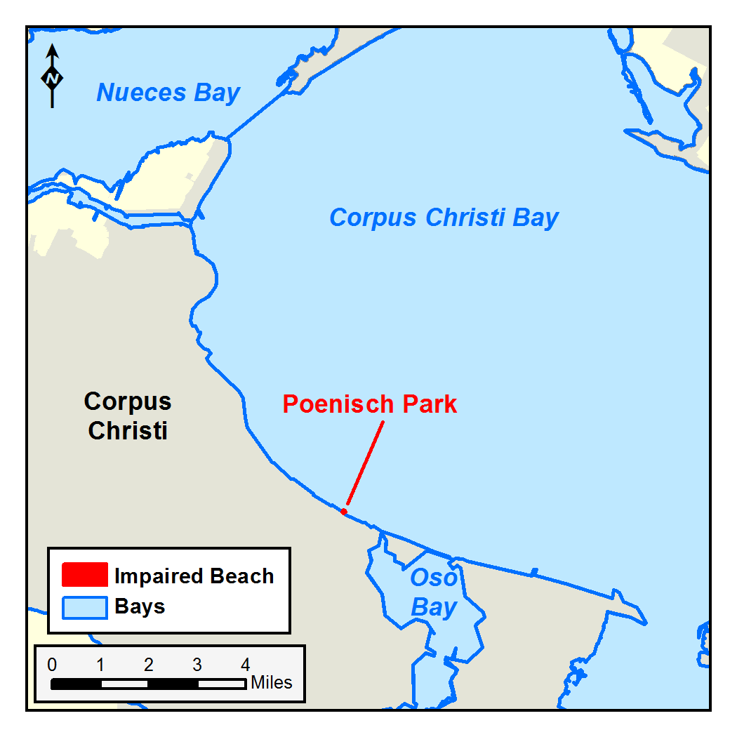
Several public beach parks along Corpus Christi Bay are monitored as part of the Texas Beach Watch Program . Data assessed from this program indicated bacteria concentrations were higher than the criteria for protecting the contact recreation use at Cole Park, Ropes Park, and Poenisch Park beaches. These beaches correspond to Segments 2481CB_03, 2481CB_04, and 2481CB_06 of the Texas Bays and Estuaries Basin. When bacteria counts are greater than the criteria, Texas Beach Watch recommends that people be advised not swim in the area.
To address these concerns, TCEQ and stakeholders developed TMDLs for the waters adjacent to Cole Park and Rope Park beaches, and are developing a TMDL for waters adjacent to Poenisch Park. Stakeholders are also working with the Texas A&M-Corpus Christi to develop one I-Plan to improve conditions at all three beaches.
Watershed Description
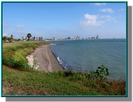
The beaches being assessed for this TMDL project are in Nueces County, in the City of Corpus Christi, adjacent to Ocean Drive.
Corpus Christi bays and estuaries are nursery grounds for fish and shellfish, and supply essential food and habitat for birds, fish, and other plants and animals. They are also home to ports, marinas, and commercial shipping activities. Corpus Christi beaches and estuaries are popular destinations for fishing, boating, swimming, sand-castle building, and birdwatching.
Get Involved
In all its projects, the TCEQ seeks to gather opinions and information from people who represent government, permitted facilities, agriculture, business, environmental, and community and private interests in the watershed. The Center for Coastal Studies at Texas A&M University-Corpus Christi is coordinating participation in these projects.
Throughout the project, the City of Corpus Christi, Nueces River Authority, the Coastal Bend Bays and Estuaries Program, and all other stakeholders and communities that use and affect these public beaches were engaged in developing a strategy to improve water quality.
The Harte Institute at Texas A&M University–Corpus Christi coordinated participation in these projects. Meetings about the project are open to everyone. Stay tuned to the Corpus Christi Regional Water Quality Implementation Plan website for notices of meetings and all meeting records.
Approved I-Plan
Community stakeholders worked together to create the I-Plan. The Commission approved the stakeholders' plan on Aug. 6, 2025.
- Corpus Christi Regional I-Plan
- Response public comment (two comments received)
Adopted TMDLs
Adopted TMDL for Poenisch Park
The Commission adopted this TMDL on Aug. 6, 2025. EPA approved it on Oct. 15, 2025, at which point it became an update to the state’s Water Quality Management Plan.
- One TMDL for Poenisch Park
- Response to public comment (one comment received)
Adopted TMDLs for Cole Park and Ropes Park Beaches
On July 28, 2021, the Commission adopted the TMDLs for Cole Park and Ropes Park beaches. EPA approved them on Jan. 31, 2022, at which time they became an update to the Water Quality Management Plan for the State of Texas. Community stakeholders are working on an I-Plan that will improve conditions at all three beaches in the watershed.
-
Two TMDLs for Indicator Bacteria in Corpus Christi Bay Beaches, Cole Park and Ropes Park
Segment 2481CB; Assessment Units 2481CB_03 and 2481CB_04 - Response to Public Comments on the TMDLs for in Corpus Christi Bay Beaches, Cole Park and Ropes Park
Reports
Cole and Ropes Park Beaches
Documents are provided in PDF.
- Technical Support Document for the TMDLs
- Interim Monitoring Report, 2012 summarizes the data collected from February through July 2012. All data was collected and analyzed by the Center for Coastal Studies at TAMU-CC.
- Interim Monitoring Report, 2011 summarizes the data collected from May through August 2011. All data was collected and analyzed by the Center for Coastal Studies at TAMU-CC.
-
Historical Data Review and Site Assessment August 2011, Center for Coastal Studies
Characterizes the Corpus Christi Bay watershed and summarizes data collected in the past. Describes the monitoring plan for collecting current data to support development of TMDLs for Cole Park and Ropes Park beaches.
Poenisch Park
Contact Us
Please e-mail tmdl@tceq.texas.gov, and mention the Corpus Christi Beaches project in the subject, or call us at 512-239-6682.