Arenosa Creek

Photo Courtesy of the Texas Water
Resources Institute

Counties: Victoria, Jackson, Lavaca
Parameter: Bacteria
Basin: Bays and Estuaries
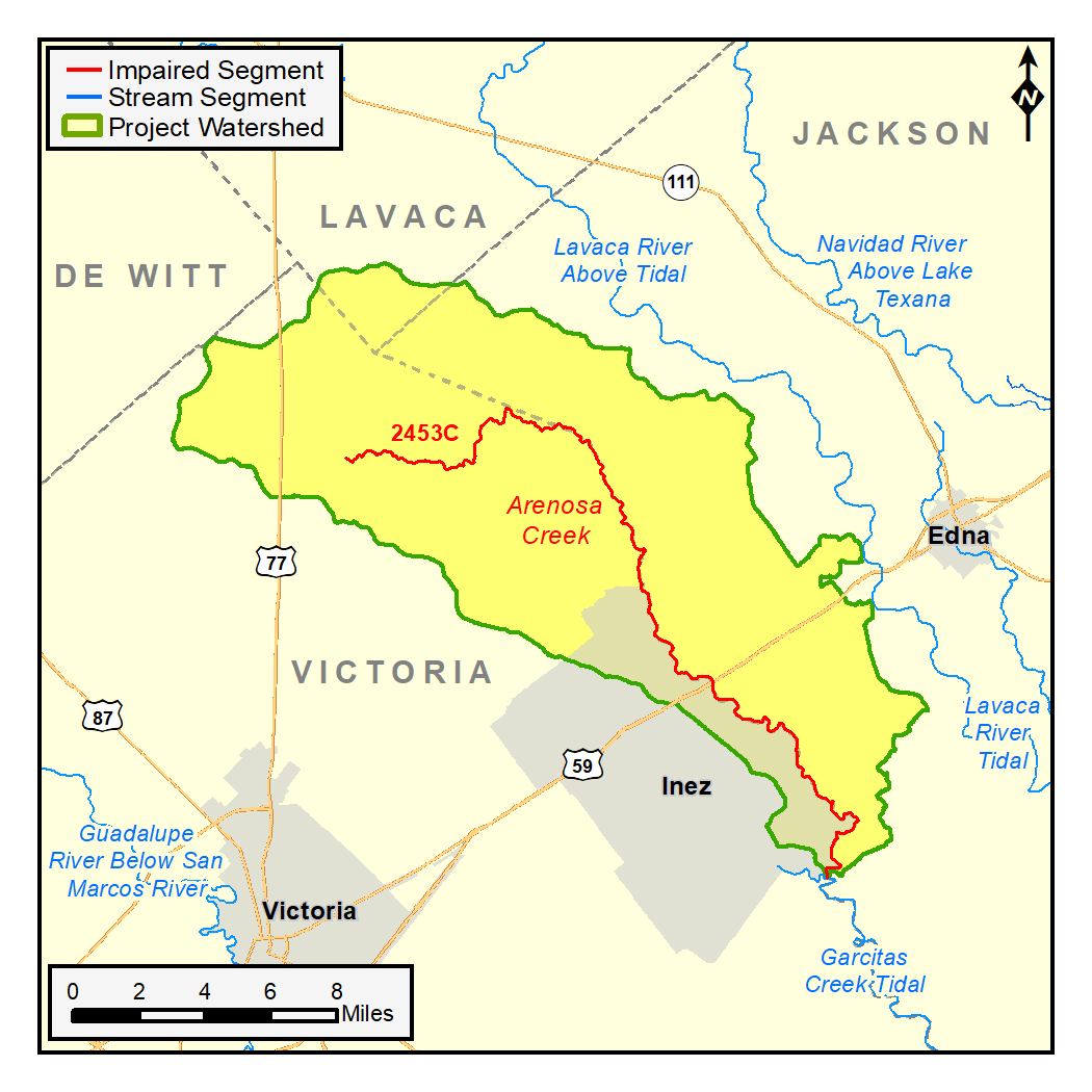
Segment: 2453C
Assessment Unit (AU): 2453C_01
On this page:
- Background and Goal
- Watershed Description
- Get Involved
- Adopted TMDL
- Approved I-Plan
- Reports
- Contact the TMDL Program
Background and Goal
Since 2010, high concentrations of bacteria, which are found in both human and animal waste, have been observed in Arenosa creek. The presence of these bacteria may indicate a health risk to people who swim or wade in the creek—activities referred to as “contact recreation”—in the Texas Surface Water Quality Standards.
The goal of this project is to improve water quality in order to protect recreational uses. Toward that goal, TCEQ and stakeholders are developing a TMDL and an I-Plan to reduce bacteria in the creek.
Stakeholders are also working with Texas Water Resources Institute (TWRI) to develop a watershed protection plan (WPP) for the larger Garcitas Creek watershed, of which Arenosa Creek is a tributary. The tidal portion of Garcitas Creek has been identified as having low dissolved oxygen concentrations.
Watershed Description
Arenosa Creek (Segment 2453C) is located on the Texas Gulf Coast and lies primarily between the cities of Victoria and Edna. The segment includes only one AU, 2453C_01. The city of Inez is partially within the watershed.
The headwaters of Arenosa Creek begin in Victoria County at J2 Ranch Road. The creek flows approximately 33 miles southeasterly until it meets Garcitas Creek. The drainage area of the watershed is about 172 square miles and falls mostly in Victoria County (52%) and Jackson County (45%); Lavaca County includes about 3% of the watershed.
Get Involved
Staff from the TWRI have been working with communities, interest groups, and local organizations to distribute information about this project and involve stakeholders in developing the I-Plan for watershed improvement. All public meetings about this project are open to anyone interested. Watch for meeting announcements here and on the TWRI website .
Approved I-Plan
Stakeholders created the I-Plan with support from TWRI and TCEQ. The Commission approved the I-Plan on Aug. 11, 2021.
- I-Plan for One TMDL for Indicator Bacteria in Arenosa Creek, AS-208
- Response to Public Comments on the I-Plan for Arenosa Creek
Status of Activities
TCEQ provides opportunities for stakeholders to report on progress and changes in the watershed. Tracking of implementation progress allows stakeholders to evaluate actions taken, identify actions that may not be working, and make any changes as necessary.
- Year One Implementation Status Update, June 2023
- Year Two Implementation Status Update, September 2024
Adopted TMDL
The Commission adopted the TMDL on Aug. 11, 2021. EPA approved the TMDL on Feb. 2, 2022, at which time it became an update to the state's Water Quality Management Plan.
- One TMDL for Indicator Bacteria in Arenosa Creek, AS-209
- Response to Public Comments on the TMDL for Arenosa Creek
Reports
TWRI staff completed a technical report in 2018 that compiled and analyzed all available bacteria data and considered sources of the bacteria and their relative contributions.
Technical Support Document, AS-203, October 2020
Contact the TMDL Program
Please email tmdl@tceq.texas.gov, and mention Arenosa Creek in the subject line. Or call us at 512-239-6682.