Petronila Creek
Counties: Jim Wells, Nueces, Kleberg
Parameters: Chloride, Sulfate, Total Dissolved Solids (TDS)
Basin: Nueces–Rio Grande Coastal
Segment: 2204
On this page:
- Background and Goal
- Watershed Description
- Get Involved
- Partners
- Approved I-Plan
- Adopted TMDLs
- Trend Report
- Photo Gallery
- Contact the TMDL Program
Background and Goal
In 2000, water quality testing found elevated levels of chloride, sulfate, and TDS in the creek. High concentrations of these salts are indicators of general water quality that are not tied to a specific use, but may affect several uses.
For example, too much chloride can cause a bad taste in drinking water, harm plumbing, and increase the risk of hypertension in humans. Large quantities of sulfate can cause drinking water to smell or taste bad. High concentrations of dissolved solids can be toxic to species that live in fresh water.
In response to these conditions, the TCEQ completed a TMDL project to determine the measures necessary to restore water quality in these streams. A TMDL determines the amount (or load) of a pollutant that a body of water can receive and still support its designated uses. The load is then allocated among the sources of pollution within the watershed, and measures to reduce pollutant loads are developed as necessary.
A variety of man-made and natural sources can be responsible for elevated levels of chloride, sulfate, and TDS. For example, a common man-made source of dissolved solids is brine, a by-product of oil production. Salt cedar, a natural source of TDS, is an invasive, non-native plant species whose high rate of water consumption creates imbalances in the soil, causing higher concentrations of unwanted substances.
The goal of this project is to improve water quality in the creek by implementing TMDLs.
Watershed Description
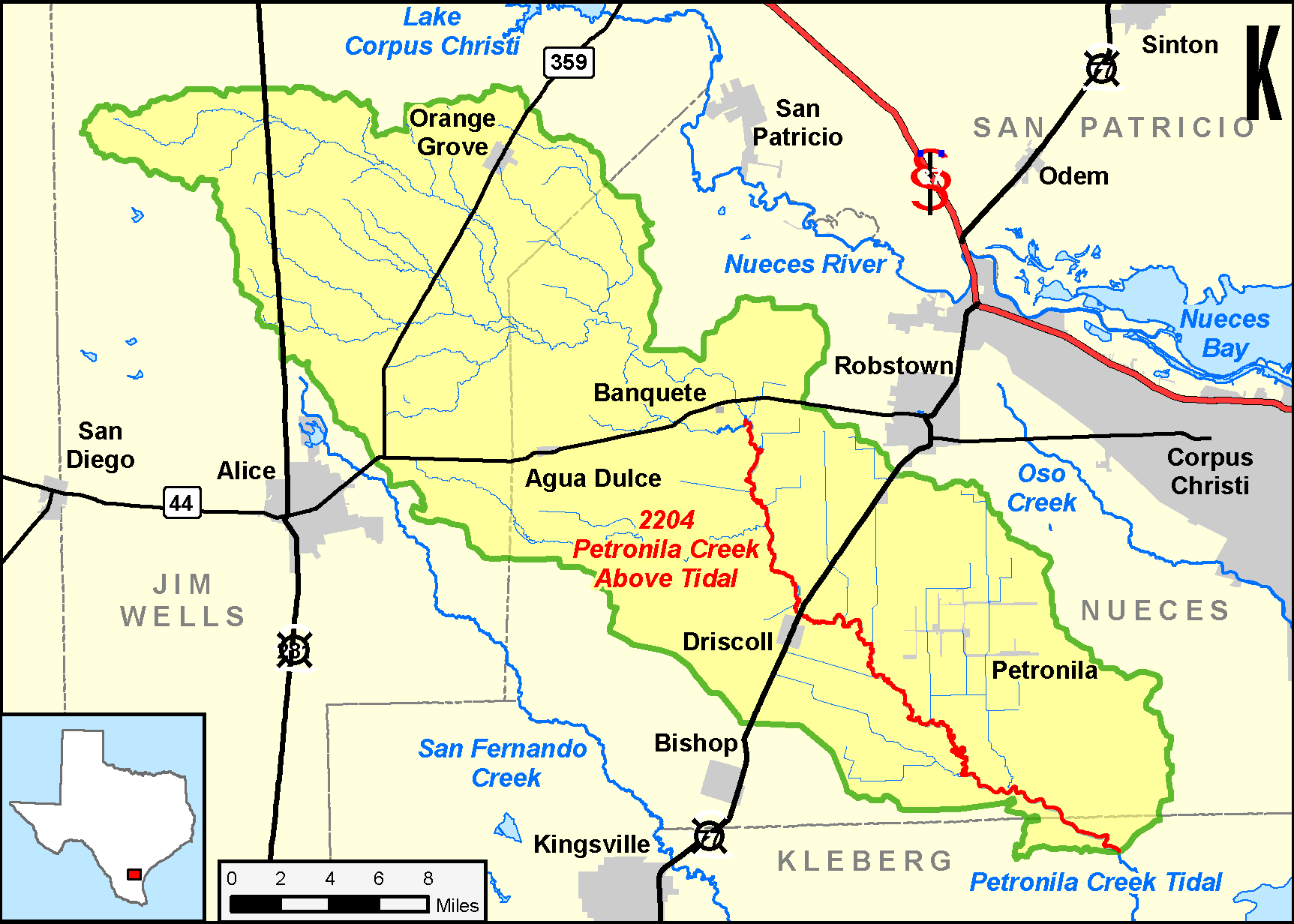
Petronila Creek, Segment 2204, is a 44-mile freshwater stream spanning Kleberg and Nueces counties. Located southwest of Corpus Christi, Petronila Creek is part of the Baffin Bay watershed. The surrounding terrain varies from flat with local shallow depressions to some locally dissected rolling areas. It is surfaced by clay and sandy loams that support water-tolerant hardwoods, conifers, grasses, some scrub brush, and cacti.
Get Involved
People who live or work in the watershed, or stakeholders, worked closely with the TCEQ and the Nueces River Authority on the TMDLs and I-Plan to improve the creek. Contact the TMDL Program to find out about ways you could be involved.
NEWNRCS Texas accepting applications for the Petronila Creek Nutrient Reduction Project
The U.S. Department of Agriculture (USDA) Natural Resources Conservation Service (NRCS) in Texas is accepting applications for the Petronila Creek Nutrient Reduction Project in Nueces County, Texas. Through funding provided by the Deepwater Horizon Natural Resource Damage Assessment (NRDA), this project provides financial assistance to agricultural producers to improve water quality through the development and implementation of conservation plans and practices.
To be eligible you must own or operate agricultural lands in Nueces County, Texas, within three priority HUC-12 watersheds: City of Concordia-Petronila Creek, Gertrude Lubby Lake-Petronila Creek and Chapman Ranch Lake-Petronila Creek.
To apply, contact NRCS staff at the Robstown Service Center, 548 S. Highway 77, Suite B, Robstown, Texas, or by phone at 361-387-2533, ext 3.
Partners
- Nueces River Authority
- Nueces County Drainage District 2
- Texas Railroad Commission
- Office of the Secretary of State , Texas Border and Mexican Affairs Division
- Texas Stream Team
- Coastal Bend Bays and Estuary Program
Approved I-Plan
The commission approved the original I-Plan on Oct. 10, 2007.
- I-Plan for Three TMDLs for Chloride, Sulfate, and Total Dissolved Solids, Petronila Creek Above Tidal, Segment 2204
- Response to Public Comment on the I-Plan
Revised I-Plan
In 2012, the Nueces River Authority (NRA) began working with stakeholders to review the Implementation Plan and its progress. Through a series of public meetings, NRA worked closely with stakeholders to gather information and form work groups to focus on specific aspects of the plan. In 2014, the stakeholders prepared a revised I-Plan to continue their efforts in improving local water quality.
Adopted TMDLs
The commission adopted three TMDLs for Petronila Creek on Jan. 10, 2007. The EPA approved them on March 14, 2007, at which time they became part of the state’s Water Quality Management Plan.
- Three TMDLs for Chloride, Sulfate, and Total Dissolved Solids in Petronila Creek Above Tidal, Segment 2204
- Response to Public Comment on the TMDLs
Revisions to TMDLs
From time to time, it is necessary to revise TMDLs to account for changing conditions in the watershed, such as new or amended permits, or urban growth, or to correct oversights in the original TMDL report. Revisions to the load allocations in TMDLs are made via the state’s WQMP, which is updated quarterly.
The WQMP provides projected effluent limits for use in planning and permitting activities under the Texas Pollutant Discharge Elimination System (TPDES). The TCEQ reviews all applications for new and amended permits for conformance with applicable portions of the WQMP, including adopted TMDLs.
Updates
Updates are made to account for changing conditions in the watershed, such as new or revised wasteload allocations, permits that have been canceled or have expired, or changed facility names. Updates use the same units of measure as the original TMDL.
- July 2022, Appendix VI, page 29
- April 2021, Appendix VI, page 24
- July 2016, page 47
- January 2009, pages 10-12
- October 2010, Appendix II, page 13
WQMP updates may be viewed in person at the TCEQ Library, Building A, 12100 Park 35 Circle, Austin, Texas. Electronic versions of updates published from 2014 through present are available on the Texas State Library and Archives Commission website .
For WQMP updates prior to 2014, use the TRAIL Search engine as outlined below. The main search box on the page will only conduct a simple search with no exclusionary parameters and should not be used.
- First, limit your search to TCEQ only. Do this via the advanced search feature on the left of the page. To limit a search to TCEQ content, enter www.tceq.texas.gov or www.tceq.state.tx.us into the “From the Host” search box.
- Refine your search to narrow down results. The other search boxes on the left of the page allow for search terms to be included, excluded, or used in an exact phrase search. Date ranges can be used as well.
Trend Report
Photo Gallery
- Photos of Petronila Creek: pictures of various sites and conditions.
Contact the TMDL Program
Please e-mail tmdl@tceq.texas.gov and mention the Petronila Creek TMDL project in the subject line. Or call us at 512-239-6682.


 Back to top